
Whilst much of Berg Street has been converted into commercial premises, many of the old residences survive in the face of the onslaught. The album illustrates the many homes and businesses from Pine Street in the west running all the way along Berg Street to the Eastern most end.
87 Photos

This album has many of the older residential homes that still exist in the CBD. Included is Rosehurst Cottage at 239 Boom street that has featured a signature garden established by the late Lorraine Kettley and the Voortrekker ,oldest house, at 333 Boom Street which was granted to Petrus Gerhardus Pretorius on 8 April 1846. The Model Infants School which is now Administration offices for the education department is also featured.
116 Photos

Boshoff Street, which runs West to East is a main route through PMB with many commercial businesses in the west and some older residences on the eastern end. This gallery has images of the Boshoff Methodist church,residences and photos of the commercial area. Boshoff Street was named after Jacobus Nicholas Boshoff who was Landrost & Chairman of the Volksraad prior to 1855. he then became 2nd President of the O.F.S and later returned to farm near PMB. He is buried in the Commercial Road Cemetery.
43 Photos

Bulwer Street, named after Lieut. Governor Sir Henry Bulwer has images of some of the residences alongside the street.
18 Photos

Burger & Leighton Streets are a feast of some of the older residences that grace the City.Some of the stunning old residences number 167/181 Kelvin House/366 Burger Street (Voortekker Huisie)/211/27/35/ and many more. Also featured is the Royal Hotel,Traffic training centre, St Mary\'s Chapel, the original Girls Collegiate,Joan Tenant House and the Old Prison which is now a fascinating Museum.
146 Photos
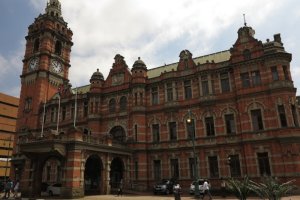
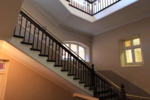
PMB City Hall,in Church Street, is a large Victorian structure reaching a height of 47m. It is reputed to be the largest brick structure and has the largest pipe organ in the Southern Hemisphere.The first City Hall built in 1893 burnt in 1895. The new hall was opened in August 1901 by The Duke of Cornwall.The City Hall has a magnificant interior with a Grand Hall, many stain glass windows of the period,office bearer boards,monuments and well fitted out Council Chambers including the Mayor\'s office. Adjacent to the City Hall is the Carbineer Gardens,Tatham Art Gallery and other Monuments. This Gallery features many of the above items and the exterior views.
108 Photos

Chapel Street, running West to East in the CBD is well named, with many churches such as the Wesleyan Metropolitan (Methodist), Baptist, First Church of Scientists, Fellowship and the deconsecrated church on the corner of Loop & Longmarket Street. Chapel street has many old, ornate buildings like Geen & Richards on the corner of Chapel and Church Street, Russel Girls High, the YWCA and many of the smaller residences towards Victoria Road. This gallery also features general street views.
73 Photos

This album has images of the city home of Thomas Joseph Baynes, who farmed on Nel's Rust (now Baynesfield Estate) near Richmond. The well maintained house is now used by attorneys.
16 Photos

This part of the City from Boshoff Street down Church street towards the N3 comprises many commercial properties and a few old residences managing to survive being squeezed out. The album relies mainly on street scenes to capture the contemporary state of this main arterial link into the City Centre.
35 Photos

The album features some important landmarks in this main street of the City. The Ghandi Statue commemorates the centenary of Ghandis ejection from the train on 6 June 1883 in PMB and his part in the struggle for emancipation. The Presbyterian Church was started in 1852 and completed in 1854. This is one of the oldest buildings in PMB but is no longer used for services. St Peters Church was designed by the wife of Bishop Colenso where he is buried . On the site is the new Cathedral.
85 Photos

This gallery contains images of many of the older and more iconic buildings in PMB such as Edwardian Colonial Building (1894),the old Herbert Baker designed Presbyterian Church (1851), Edgars (formerly Irelands - 1897), Standard Bank (1881), FNB (1917), St Peter\'s Church (1851),Geen & Richards (formerly F. Perry & Co - 1899)and many more. This gallery has images of the street from the City Square all the way up to the Railway Station.
142 Photos

The Square on the corner of Church & Commercial Roads commemorates a number of military campaigns. The War Memorial Arch commemorates those who fell in WWI & WWII. The Arch was dedicated in 1922 & again in 1947. The Field guns were captured in the GSWA campaign. The bronze plaques were stolen in 1994 but have been replaced in marble in 1999. The Zulu War Memorial commemorates those who fell in 1879. The monument was shipped from Italy and erected in 1885. The other monument is the natal Volunteers War Memorial commemorating the 134 local Colonists who died during the South African War. The monument is mounted by the winged figure of victory and has eight bronze panels with names and frescos. It was erected in 1907 (Ref: Steve Camp - Historic Pietermaritzburg)
59 Photos

Commercial Road (now Albert Luthuli) runs from west to east through the centre of PMB - There are many commercial buildings featured in this album which also features the Tatham Art gallery and Magistrates Courts.
87 Photos

The Natal Carbineers Garden of Peace commemorates the members of this unit who gave their lives in the many campaigns they participated in. This album has images of the Carbineers monument commemorating those who died during the Langalibalele Rebellion of 1873 and also of the 45th Regiment (Sherwood Foresters) who served in Natal between 1843 and 1859.
18 Photos

The older residences in Deanery Lane were built between 1850 and 1935, mostly in the apricot coloured red Maritzburg brick. The lane was originally a footpath between the original long erfs allocated to the burghers.The Old Deanery co-educational school existed until 1894 and is the origin of the name of the lane. Also featured are buildings in McCallum, Havelock and Raven streets.
41 Photos

PMB East Street is the last major street running parallel to the N3 at the lower end of Church Street. The street has hostels and commercial outlets on the northern end and on the southern side the Midlands Medical Centre, Soofie Habbebia Mosque and the Nizamia Islamic School as prominent features.
30 Photos

Greylingstraat is named after Piet Greyling, the son in law of Piet Retief and was tasked with the layout of PMB in 1838, following the massacre at Bloukrans. The album has images of some of the remaining older homes and churches in this street.
59 Photos

Henrietta Street runs between Longmarket and Bulwer Street and has some good examples of the smaller brick cottage like homes from early PMB.
14 Photos

This Gallery has some of the interesting feature buildings in Longmarket Street. Government House dates back to 1845 when it was built for the Lt. Governor in thatch and then followed in later years and the more Edwardian design in the early 1900's. It has recently been renovated and currently used by Unisa. Parliament House foundation stone was laid in June 1887 and ready for use in 1889. It was built on the site of Bishop Colenso's church of St Mary's in classical style. The Legislative Council buildings foundation stone was laid in 1898 and completed in 1900. The General Post Office built in Edwardian style was built in 1903 and topped with turrets, parapets & domes. Also in this album is the Longmarket Presbyterian Church with many commemorative plaques,The Cathedral of the Holy Trinity and the Natalia Administration building.
119 Photos

The old Market Square has very little remaining from the past other than the City Hall & Carbineers garden of Remembrance which are in their own albums. The other old landmark is Publicity House designed by JS Brunskill and completed in 1884 for use as a Police Station with 8 cells amongst other rooms.The old bell used to toll at 9am each day to announce the native curfew. The rear of the building was used as a fire station from 1884 to 1934 when the Police and Fire Department vacated the premises. Today the building is used as a Publicity Association.
24 Photos

This gallery of Longmarket Street has many street views but also images of the many old homes and businesses found along its length. Some examples are the Natalia building built in 1971, the Reids Cabinet Works built 1901(No 214),Amafa House No 195 - 1897 (formerly YMCA) ,and the Victoria Club & lane.
131 Photos

The Voortrekker (Msundusi) Museum has many buildings and displays relating to the Voortrekker era. Featured is the Church of the Vow built in 1840 to commemorate the defeat of the Zulus at Blood River in 1838. There are statues of Piet Retief (1780 - 1838)(murdered by Dingaan) and Gert Maritz (1797 - 1838) both of whom died before the founding of PMB. Andries Pretorius House was originally built on his farm Welverdiendt outside PMB and rebuilt on this site. Onsite is the newer NGK Church and the main building housing the extended museum.The Museum was formerly the Longmarket Street Girl\'s School.
61 Photos

This album covers many of the Loop Street residences between Boshoff street and the N3 to the north of the city. Also are images of the St Marian Centre. This album illustrates the simple middle class homes many of which date back to the earlier parts of the 20th Century.
41 Photos

This album features Macrorie House,The Imperial Hotel and Boys'Model School in Loop Street. Macrorie house, now a Victorian Museum was built in 1852 and was bought by Bishop Macrorie in 1873 and owned by them until 1898. Inside the Museum (1975) is a small chapel and many Victorian relics. Boys' Model School started as Pietermaritzburg High School in 1866 until 1887 when it moved to College Road. It was at this time it became Boys' Model School which was founded in 1949. The school became a remedial school which closed and is now (2013) being renovated. The building is in Gothic Revival style. The Imperial Hotel started off as a large house in 1877and converted to a hotel in 1878.It was renamed The Imperial Hotel after the French, Prince Imperial Napoleon who frequented the establishment. In 1897 , 85 bedrooms were added and over the years further alterations were done. The Hotel was also a frequent watering hole in the 1970's (Emily Pankhurst and Stables Bars). Included also are interior images of the Natural History Museum opposite the Imperial Hotel in Loop Street.
63 Photos

St John\'s United Church is the result of the Union in 1997 of two churches, the PMB Congregational Church & the PMB Presbyterian Church. The Loop street building dates back to the 1890\'s and were built for Anglican Order of John the Divine. The old Presbyterian Church is in Church Street and is no longer a church venue. St Mary\'s was the first Catholic Church built in 1852. The Prince Imperial\'s body lay in state in this church in June 1879. The Chapel has an interpretive section giving the history of the Prince Imperial\'s time in South Africa. On the opposite side of the road in Loop Street is the more recent St Mary\'s Church.
48 Photos

This album of Loop Street has too many feature buildings to mention them all but some of them are the Victorian houses like 123/133/180/196/25 Loop Street.Of special note is at 122 Loop Street - Overpark - which was built in 1862 and was originally the Presbyterian Manse but now restored houses a professional practice. The old St Anne\'s Hospital, now abandoned, features as does the Natalia Administration building . Loop Street Police Station, an Edwardian building was completed in March 1905 as railway offices,then used by the University (WWI), police barracks and now the Central Police Station. The Buchanan Street Swimming Bath was built in 1895/6 which is at 21 Buchanan Street off loop Street and still utilised today.
109 Photos

This gallery has some of the remaining homes in the small side streets in the CBD.
11 Photos

Pietermaritz Street is named after Pieter Mauritz one of the early trekkers to cross over the Drakensburg in 1837. and who was murdered by Dingaan. The notion that the city was also named after Gerrit Maritz has been challenged. This album has street views and photos of the many older houses that still exist today. One of the houses featured is the Victorian, 131 Pietermaritz street built by GJ Cundill some time shortly after 1905.
101 Photos

Pine Street runs east to west and has many old PMB red brick homes. It also has the Joliffe swimming pool and the (formerly College of Education)Edendale Nursing College that has recently been refurbished to a pristine state.
42 Photos

The Prince Alfred Street album features mainly the old \"Maritzburg\" Victorian homes from Prince Alfred Street in the south above Camps Drift all the way along to the North of Boshoff Street. Also included is the old Greys Nursing Home and Hospital most of which is now used by the Museum Services. There are a wide range of homes all along this interrupted street.
80 Photos

These street mainly feature the Churches like St Anthony\'s Catholic Church in Retief Street and the Sri Siva Subramonial Marriamel Temple in Williams Street, along with some remaining residences.
18 Photos
Russell High School founded in 1879 has had a few name changes over the years. Initially Girls Model Primary School it was renamed Berg Street Intermediate School in 1828 and finally Russell High School in 1941 after the Superintendent of Education who nurtured the original school. Although the school caters for girls it has over its history enrolled boys, one of whom was Dr Alan Paton. Presently the school has 550 girls and has built up a reputation for its arts and drama. The main school structure is a national monument with its striking exterior features and the large high ceiling interior corridors and open halls. The Gallery features the buildings ,Honours Boards, memorabilia, photographs and some of its contemporary art prepared by the scholars.
112 Photos

Stranack Street in the PMB CBD is one of the many small side streets in the City. This gallery features some of the quaint old residences that have survived the redevelopment of the inner city.
13 Photos

The foundation stone for the Sanitorium initiated by Bishop Jolivet was laid in 1897 and opened in1898. The San was run by Augustinian Nuns who also ran a garden and dairy cows. In 1906 the San had 50 patients.The hospital had several additions made to it over the years and the front, Loop street entrance bears the year 1930. The Nuns ceased to operate in 1966 when the San was taken private and then in 1972 it was taken over by Greys Hospital and renamed St Anne's. This in turn closed when Greys Hospital moved to its new position on Town Hill in 1984. The hospital is now derelict and this album has images of what remains in its derelict state and includes the old Chapel and Laundry Boiler Rooms.
121 Photos

These small lanes running between Church Street & Longmarket Street have some of the older CBD commercial buildings. Many of the original law firms had their Chambers in these quaint streets. The nature of the streets has changed significantly and now house Salons, Cell phone shops and the like.
43 Photos

This gallery has images of the commercial premises that have replaced the original homes in the area. Featured is the Maritzburg West sports Club and the St Patricks Anglican Church.
55 Photos

The Voortrekker Cemetery (West) in Durban Road contains many of the graves of the early settlers in Natal and PMB. This is part I of 4 parts of the graves to the west of the road and is intended to record as many of the graves as possible, many of which are becoming illegible, particularly those manufactured from sandstone.
142 Photos

The Voortrekker Cemetery (West) in Durban Road contains many of the graves of the early settlers in Natal and PMB. This is part II of IV parts of the graves to the west of the road and is intended to record as many of the graves as possible, many of which are becoming illegible, particularly those manufactured from sandstone
139 Photos

The Voortrekker Cemetery (West) in Durban Road contains many of the graves of the early settlers in Natal and PMB. This is part III of IV parts of the graves to the west of the road and is intended to record as many of the graves as possible, many of which are becoming illegible, particularly those manufactured from sandstone
140 Photos

The Voortrekker Cemetery (West) in Durban Road contains many of the graves of the early settlers in Natal and PMB. This is part IV of IV parts of the graves to the west of the road and is intended to record as many of the graves as possible, many of which are becoming illegible, particularly those manufactured from sandstone
137 Photos

The Voortrekker Cemetery (East) in Durban Road contains many of the graves of the early settlers in Natal and PMB. This is part I of V parts of the graves to the east of the road and is intended to record as many of the graves as possible, many of which are becoming illegible, particularly those manufactured from sandstone
149 Photos

The Voortrekker Cemetery (East) in Durban Road contains many of the graves of the early settlers in Natal and PMB. This is part II of V parts of the graves to the west of the road and is intended to record as many of the graves as possible, many of which are becoming illegible, particularly those manufactured from sandstone
146 Photos

The Voortrekker Cemetery (East) in Durban Road contains many of the graves of the early settlers in Natal and PMB. This is part III of V parts of the graves to the west of the road and is intended to record as many of the graves as possible, many of which are becoming illegible, particularly those manufactured from sandstone
149 Photos

The Voortrekker Cemetery (East) in Durban Road contains many of the graves of the early settlers in Natal and PMB. This is part IV of V parts of the graves to the west of the road and is intended to record as many of the graves as possible, many of which are becoming illegible, particularly those manufactured from sandstone
150 Photos

The Voortrekker Cemetery (East) in Durban Road contains many of the graves of the early settlers in Natal and PMB. This is part IV of V parts of the graves to the west of the road and is intended to record as many of the graves as possible, many of which are becoming illegible, particularly those manufactured from sandstone
167 Photos

This gallery has street views of this CBD main road and some of the remaining residences many of which are now commercial premises. Also featured is the iconic Polo Club which was a well known eatery.
32 Photos