This covers KwaZulu-Natal areas west of Durban, South of the Tugela, the Midlands and to the Drakensberg. Everywhere away from the coast excluding Zululand & PMB.
————————————–
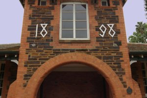
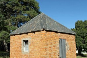
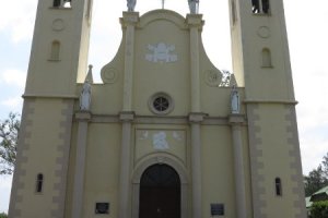
Baynesfield Estate measuring 24000ha was donated to the nation by Joseph Baynes (buried on the Estate) provided it was used for Agricultural purposes, and including for research. This gallery has images of the main house interior and exterior built 1882, and outbuildings and also of the Baynesfield District & Recreational Club. Joseph Baynes came out with his father Richard in 1850 as part of the Byrnr settlement scheme on the Divonia. His father started farming in the York area and then Joseph and other members of his family, bought Nels Rust in 1852, and by 1902 had doubled the farm size. Baynes was a progressive farmer of cattle ,dairy, pigs and horses. Sadly Joseph lost both his wives early on and had no heirs, and for this reason left his Estate in trust for the benefit of South Africans. Baynes also started the Model Tea Room in Durban & Johannesburg and produced butter and dairy products on a commercial scale. Today the farm still operates as intended and includes an agricultural training institute. Joseph and his wife are buried in the well kept Mausoleum on the Estate.
324 Photos

Bergville lies in the rich farming valley with the Drakensberg as the backdrop.Maize growing and dairy are the main agricultural focus.Bergville is also close to many of the dramatic Boer War battlegrounds, the closest being Spionkop.
74 Photos

Besters Village is a small village north east of Ladysmith. Once probably an active little village it has seen a demise along with the trading stores and railway station on the Natal - Free State line. In the surrounding areas are the remains of the farm used by the Free State Kommando in 1899 during the siege of Ladysmith at Smith's Crossing, the grave of Fred Johnson, the first Burger killed in the Boer War, the secluded grave of Private Skinner (5th Lancers) and that of a small child (De Jager), who died of scalds circa 1900 . In the Besters village is the grave & monument of Hans Don, a Boer Kommandant, who was executed by the British for killing a black. This album also has images of the rail line at various points and of the old abandoned NGR line and tunnels that lead up to Van Reenen's Pass.
121 Photos
Boston is on the road between Bulwer and Underburg. It is a small farming community and this gallery includes images of the Cemetery with monuments to those who fell in the Boer War and WWI & WWII. there are graves of the local people who died. The Moth Hall has a plaque to the fallen and a tank. Included in the grounds of the Country Club is a Pill Box , built for protection during the Bambatha rebellion.
43 Photos

Byrne Village was started by the Byrne Settlers in 1850 and this gallery features the Mary Magdalene Anglican Church established in 1853, some of the cottages and the Oaks Hotel.The bell from the wreck of the Minerva (4 July 1850) is in the graveyard along with graves of the local settlers and their descendants.
34 Photos

Bulwer on the R617 between Underburg & Boston was founded in 1885 after Sir Henry Bulwer, Lt Gen. of Natal (1875 - 1880). The town was the scene of much logging of the forests, in particular for the giant Yellowoods.The Marutswa Forest hike takes you through the remains of these forests which have a varied birdlife. The village has many old late 1800 residences and commercial buildings. Amongst the historical sites are the old hotel, the now abandoned Bulwer prison, Magistrates Courts and the Yellowood Church built in 1886. There are two main schools, the Bulwer Primary and the Pholela High started in 1890 by the Church of Scotland. The Mountain Park Hotel is a favourite cosy getaway and some of the hotel is reputed to have been built by Italian P.O.W.\'s during WWII. This Gallery contains images of all these features and street scenes.
163 Photos

Camperdown & Cato Ridge are small villages that fell on the old road and rail links to the inland. Once important stop overs for travelers, these villages are now more support centers for the local farmers, and people living in the adjacent communities. The album also features a local farm, close to Camperdown, some rail houses and the Church of the Resurrection and all of the graves in the cemetery.
113 Photos

Eden lassie, lies in the rural Tala Valley a short 40 minute drive from Durban. Eden lassie has a chapel and large functions facility with views over the Tala valley and its well kept gardens.
47 Photos

Cedarville lies between Kokstad and Matatiele and is 278kms from PMB. The Town Hall dates back to 1931 and the Dorp has several old churches and also trading stores. The area is better known for its scenic beauty.
64 Photos

Charlestown was the terminus of the Natal Railways before the Boer War and visited by Lord Milner & Lord Chamberlain at the time. It was the first Natal town taken over by the Boers due to its proximity to the Transvaal and Orange Free State. After the war the town thrived for a while with several churches, two hotels and many farming related associations. Once the Railway to the Reef went through, the town went into decline and very little remains of its glory days. Charlestown is in close proximity to the famous Majuba battle site - 27 Feb 1881 - ( See Gallery under Boer War)
45 Photos
Umsolusi Private Game Reserve is 10 Kms south east of Colenso on the Bloukrans River. The area was settled in the 1830\'s and developed as a farm , more latterly as a game reserve. There are remnants of the old farm buildings dating back to the 1800\'s. There are also old graves on the farm that relate to the early farming activities. Sadly the farm has had land claims over it - some settled, however the local community have seen fit to burn many of the lodges,some of which they inherited as part of the process. The white Rhino have been removed as their well being was threatened.
44 Photos

Crieghton near Ixopo is a small farming village which was set out in 1865 and named after Sir Henry McCullum's wife (nee Creighton).McCullum was the Governor of Natal in 1901. The town has a hotel, farm support businesses and a Country Club all featured here. The town is also well known for the aloe festival which normally takes place in July. The town has operating steam trains which do outings from the town centre on an organised basis.
98 Photos

This gallery covers the rural towns of Dalton, New Hanover and Schroeders, Fawnleas & Glenside. The area has a strong German influence evident in its buildings. The area is a strong sugar growing area with several mills operating. There are images of the commercial buildings, churches and some of the older houses in these towns.
85 Photos


Donnybrook is a small rural town to the south of the Umkomaas River and inland from the sea. The town has seen better days as evidenced by the abandoned railway junction that used to see it\'s farm products railed to factory door. There are a few small commercial enterprises eking out a living and providing support to the local community. Even the St John\'s Apostolic Church has seen its congregation dwindle. This Gallery gives a taste of what it is, and what it once was.
69 Photos

The Railway station was built at Inchaga in 1895 and the hotel in 1903. The Umgeni Steam Railway runs excursions from the station. Drummond in the 1000 Hills route has many old establishments featured in this Gallery including the Station Masters House, Halfway Supply Store,Elize Kingham\'s and Old Butchery, the Old Mill Cottage and 1000 Hills Hotel (1936).
157 Photos

Durnacol & Danhauser are both small villages in Northern Natal. Dannhauser is named after Renier Dannhauser who purchased the farm from the Government in 1872. The two villages became dependent on serving the coal mines in the area but both villages have suffered a decline with the closing of the mines. There is a small remaining population who eke out a commercial living.
91 Photos

Eston and Mid Illovo are primarily farming areas with sugar cane and vegetables the main outputs. This Gallery features the Illovo Mill & Church, Eston Village and the Trappist Mission of Einsiedeln. (R624). The small trading stores of Umbumbulu are also featured.
53 Photos

Franklin, in East Griqualand is a small village on the railway line that services the local farming community. The village has a couple of churches, filling station, agricultural hall and the 1927 Franklin hotel. The railway station is no longer in use.
36 Photos

Geluksburg lies at the foot of the Ntintwa Mountains, about 26 KM from Bergville. The small hamlet of less than 200 residents was founded in 1908, and is well placed to visit the many mountain passes in the area. Some of the passes include Middledale , Oliviershoek, Bezuidenhout, and van Reenens. The area is also very scenic and the hamlet has accommodation like The Homestead and Gina's that are good value and well run. Geluksburg is also close to the "Lost Valley" where a few of the Voortrekkers broke from Piet Retief and lived, and their descendants, a solitary life until the 1950's. It is claimed that these folk were unaware of the Boer War, WWI & WWII. The hamlet consists of many old ruins of buildings and scattered residences on large stands.
127 Photos

Greytown , named after Cape Colony Governor Sir George Edward Grey was originally settled in the 1850's. This site has images of many of the old structures including homes, churches, Municipal establishments and street views. The site has images of the Gen. Louis Botha's birthplace monument, Fort Menne and the grave of Sarie Marais Especially featured is the Greytown Museum with all its memorabilia, in its historic building, the King George VII sport fields, and Greytown Hoerskool.
316 Photos

Greytown old Cemetery to the south of Town has graves of many of the original inhabitants within its bounds. Names such as Van Rooyen, Handley, Tatham, Martens and Maritz feature regularly. There are also a number of military graves of members of the UMR, NMP and 24th Regiment. Not all graves have been covered but an attempt has been made to record the older graves, many of which are showing the signs of age and neglect.
211 Photos

Hammersdale is a small village on the old main road that many years ago had a thriving textile industry.The local Township of Mpumalanga provided much of the labour for this declining industry. Mpumalanga was the epicentre of some vicious clashes between Inkatha & the ANC prior to 1994.
53 Photos
Hermansberg was established by German Missionaries and settlers. The Mission was established in 1855. Deutsche School in 1856 and the Evangelical Peter - Paul Church in 1868. This gallery has images of the two churches, the Deutsche school, and the museum.
41 Photos

Himeville was named after Sir Albert Hime , the Prime Minister of Natal in 1899. Himeville Museum was the old stone loop holed fort built for protection but never tested in battle. The residency was built in 1898 and used by successive Magistrates but is now in a state of neglect. The main church in Himeville is the St Michaels & All Angels Church. Opposite the church is the Moth Memorial. A popular watering hole is the Himeville Arms, which is filled with memorabilia, including posters from the annual Splashy Fen concert held close by, annually. The local cemetery has the graves of many of the original settlers. The gallery also has some landscape images of the local area. Also included in the album are images of Kenmo lake which is open to the public.
198 Photos

This gallery has images of the many buildings in Ixopo, Highflats, and the majestic buildings of the Trappist Mission of Mariathal and that of the Himmelburg Intermediate Combined school in the district.
157 Photos

The Bambatha Memorial commemorates the protest in 1906 against a poll tax.The uprising by Chief Bhambatha kaJangeni Zondi commenced with the ambush on 4 April 1906, and killing of members of the Natal Mounted Police at this site 23 kms from Greytown on the road to Keats Drift.The memorial is next to the road and there is a police memorial closer to Greytown. Keats Drift is a small trading town at a crossing over the Mooi River.
37 Photos

Kokstad was founded by Adam Kok III in 1872 after trekking from Griqualand West to avoid the Boers. This gallery has many images of the town's heritage. Some of the important sites are the Kokstad Museum, Adam Kok Laager (outside the town), Griqua National Independent Church, Adam Kok Memorial, band stand at the Town Hall, Cape Mounted Rifles Monument, St Anthony's Catholic Church, Royal Hotel Façade, Parish of the Holy Trinity and much more illustrating this historical town. The album also has images of the nearby Karg's trading post, Peacehaven B & B, and the Kruisspruit polo club.
303 Photos

Kokstad is named after the Griqua Chief Adam Kok II, who came from Griqualand West in the Cape Province in 1863. The Old Town Hall building is situated in Main Street, Kokstad. The building was designed by Architecct Arthur Fyfe who designed many buildings of this era , particularly in Durban. The building has a strong Colonial look with its prominent columns on the front facade and gables, and clock-tower. The Town hall opened in 1901 is used for municipal purposes and a public library. The new hall was built in 1934. In the front of the building is an elaborate monument to the Cape Mounted Rifles who served and gave their lives in the Anglo Boer War . Also in the grounds is the bandstand built of wrought iron.
28 Photos

Kranskop & Maphumulo are two small trading towns serving the rural markets of KZN. Kranskop originally Hopetown, was founded in 1894 and is on the escarpment to the Tugela River.It is named Kranskop after the sandstone outcrop overlooking the Tugela River. There are several old forts built during the Anglo Zulu War like Fort Buckingham (not featured here). Also included in the album are images of Thrings Post which still exists but featured as a gathering point during the Zulu campaigns. Also featured is Mandalay Farm and Ethembeni Store which are along the Stanger to Kranskop road. Ahrens is a small trading village and rail siding to the east of Greytown.
119 Photos

Ladysmith, the siege town of the Anglo Boer War (1899 - 1900 ), has many old late 19th century buildings. It is at the core of the many battlefields in Natal such as Elandslaagte,Colenso, Vaalkrans and Wagon Hill. The town is a busy commercial centre serving the mines and agricultural sectors. Some featured buildings in the town are the Town Hall, Royal Hotel, Old Toll House. La Verna Hospital and Museum.
176 Photos

The Farghuars farm to the north east of Ladysmith was used as the HQ for the Transvaal Commandos during the siege of Ladysmith. Also in this gallery is the Mbulwana station alongside the Klip River which was close to the Intombi Dam. The Boers attempted to dam the Klip River and in this way flood the town of Ladysmith. The British shelled the site and in this way prevented the dams completion. This gallery shows the farm house and graves of Anna & Johannes De Waal who died just prior to the Boer War.
31 Photos

Matatiele is included in this site because at various times in the provinces history it has formed part of KZN. It now falls into the Eastern Cape and this arose from a political trade-off whereby areas in the Umzimkulu area were incorporated into KZN in exchange for Matatiele region. This album has street scene images, the country Club and images of the old rail terminus. The town is a strong trading component, but does have a large school and many churches.
143 Photos

This album has images of the Loskop Railway Station and trading stores, and the near-bye small industrial area. The main focus is however on the Empangweni - Moorleigh Mission, which was established in 1863 by Missionary Heinrich Kayser . The buildings shown here comprise The Mission Press (1909), St Johanneskirche (1908) and the Gnadenkirche (1911), which were built by these German Lutheran missionaries. The Mission is also the site of two schools and two cemeteries related to the two churches.
117 Photos

Muden lies on the banks of the Mooi River and was at one time a fairly productive farming area using the abundant water resources to irrigate and grow a variety of crops and citrus.Unfortunately, poorly executed land claims have devastated this industry and the town bears evidence to this process, with derelict and run down buildings and farmhouses.This Gallery also has panoramic views of the area and images of the Zulu Isivivane on the road to Weenen. The area is very rugged and dry and without water would be very inhospitable.
61 Photos

This gallery has images of historical sites in the Newcastle area. There are two bridges of interest : The Hime Military bridge built in 1883 by Major Hime R.E., Colonial Engineer and the Buffalo river bridge built in 1898. Also in the gallery are images of Fort Mistake on the Biggarsberg Pass and old unused motel of the same name.
48 Photos

Newcastle is an industrial town in Northern KZN. Much of the older buildings have been demolished or had ugly facades attached to the structures. This gallery has street scenes and also features interesting structures such as the St Dominic\'s Pavilion, Old Armoury, Town Hall , Carnegie Library and a number of old churches.
112 Photos

Otto's Bluff & Mortons Drift are at the headwaters of the Albert Falls Dam and are a taste of what some of the farming areas in KZN look like. This album also has images of the Ukhutula Game Reserve with its self catering lodges. Ukhutula has a wide range of antelope species and other game in this magnificent reserve dominated by paper bark thorn trees. There are numerous walks and fishing on the confluence of the Umgeni and Karkloof rivers where otters can also be seen.
75 Photos

These monuments are on a district road opposite Sterkfontein Dam on the Harrismith-Oliviershoek Pass road, before descending the pass. Kerkenberg and Retiefs Klip was the spot where Piet Retief laagered prior to descending down the Ouderbergpas (now Retiefs Pass), in November 1837. His daughter Deborah wrote his name on the rocks which is portrayed here. The Kaalvoetvroue ("Bare foot women") Monument commemorates the decision of Johanna Smit, the sister of Gert Maritz (Voortrekker) to walk barefoot back over the Drakensberg Mountains, rather than submit to British rule in Natal. A diarama also illustrates the routes taken down the mountain by the different trekker leaders.
62 Photos

This Cemetery in Kings Road has the graves of some of the early inhabitants of Pinetown and graves of members of the 7th Hussars & 13th Hussars who died in 1881/2. One of the more interesting graves is that of Captain J Malone V.C. a riding master of the 6th Inniskilling Dragoons who died in Pinetown in 1883. He was one of the 600 in the Charge of Balaclava in the Crimea on 25 October 1856.
63 Photos

Doone Village in Pinetown was started on the farm Richmond, belonging to and donated by Aaron and Cissy Beare and opened in 1974, with the help of fellow Rotarians. The original farmhouse falls into the complex. This album has an image of the Founder and a few images of the front facade, gardens pool and interior facilities.
17 Photos

The images of Pinetown depicted here include street scenes of Old Main Road, Hill Street, Crompton Avenue and Dales Avenue. Also included are images of the old Railway Station, Imperial Hotel,Lahee Park and Pinetown Junction. Pinetown was originally settled by the Amatuli people but soon became the route to the hinterland and the formal settlement named after Sir Benjamin Pine around 1850. Pinetown was also a Garrison Village in 1879 and during the Anglo Boer War was used as a base Hospital. Many graves can be found in the local cemeteries. Pinetown today is a busy commercial node specializing in the motor trade and also many support industries. The new Germany images include those of the Lutheran Church and Civic Hall & Sports Club. New Germany had originally been settled as a farm growing cotton around 1848 and Jonas Bergthiel from Hanover in Germany, who arranged for the immigration of Germans is considered the founder of New Germany. There is a separate gallery of the Westville based Bergthiel Museum.
156 Photos

Paradise Valley Nature Reserve is about 100 hectares in extent and lies under the suspended N3 bridges near Pinetown. The reserve was originally the Umbilo river waterworks from 1887 to 1905, supplying Durban with its water. There is still evidence of the old dam, its spillway and the sand filter tanks that comprised the waterworks. The reserve is however now used for picnicking, river trails and there is a nature interpretative centre on site. The gallery also has images of the waterfall on the Umbilo River and the nearby Paradise Valley residential complex built in 1976. The N3 overpass was constructed in 1971.
57 Photos

Richmond , south of Pietermaritzburg is rich in heritage. This gallery has images of the Old Court House, St Mary's Anglican Church, Bambatha Memorial, Ndaleni Mission, the Richmond Byrne Museum (formerly Presbyterian Manse), Inter Party Violence monument and the St Josephine's Bridge over the Umkomaas. There are images of many of the old residences with a special feature on an early 20th century red brick residence believed to have belonged to a long standing resident of the town : Dr Mathews.
237 Photos

This gallery features the Richmond public cemetery and focused on the older graves of former members of the community.Many of the graves are illegible due to an accumulation of moss on the headstones.
153 Photos

Rietvlei & Ibisi are small villages between Umzimkulu and Kokstad. Rietvlei has a hospital, some trading stores and a derelict N.G.Church dating from 1941. Ibisi is also a small village with a police station, old Staffords Trading Store and the Ibisi Bridge built by Donald Strachan in 1901.
31 Photos

Riverside which is inland , to the west of Umzimkulu is all but a ghost town. The town was a trading centre based in the old homeland of Transkei. With the incorporation of the homelands back into South Africa, this towns reason to exist disappeared. The town now consists of derelict buildings such as the railway houses, old Riverside Hotel, run down trading stores and derelict commercial and industrial buildings. James Cole was the trader and farmer who owned the Riverside Hotel. Wally Downs and later the Moxham family owned the saw mill which closed downa few years ago. This area is also famous for its abundant Aloe Ferox, which come out in flower in June and attract sightseers. The Paton Country Rail (GMAM Garatt) runs along the Ngagwane River from Creighton to Riverside over the Aloe festival and on special occaisions.
104 Photos

The foundation stone for the Shongweni Dam, (Vernon Hooper)to the west of Durban was laid in 1923 by Walter Gilbert. The dam built to supply Durban with water was completed and opened on 15 December 1927. The area of the dam and surrounds forms part of the Umsinsi Reserves and there are camp sites, lodges ,fishing Canoeing (Umzinyathi Canoe Club) and Spirit of Adventure organization. The reserve also has many antelopes and also buffalo and a wide variety of birds. This album also features images of the Summerveld horse training track, Club House (1966) and the Summerveld Jockey Academy (1972).
164 Photos

Swartberg, in East Griqualand is a small village on the old railway line and in a farming area. The Village has a derelict station, Zwartberg Garage, St Luke's Church, and is dominated by the old Strachan's Hotel and trading store. Also featured are the farm depots and the Swartberg Farmers Association Hall and saleyards.
88 Photos

Royal Natal National Park in the northern Drakensburg has some of the most stunning scenery in this mountain range. The park has hiking, trout fishing and camping facilities as well as the well run Tendele accommodation run by Ezemvelo Wildlife. The park was give a \"Royal\" designation after the visit of the Royal Family in 1947 as guests of Field Marshall Jan Smuts. Unfortunately the hotel burnt down and this national treasure is derelict. The original hostel was built around the home of Walter Coventry in 1903. It was subsequently owned by Messrs FC Williams and then Otto Zunkel, who rebuilt the hotel, creating the hotel that became famous.
85 Photos

Thornville formerly on the farm Uys Doorns was an important rail staging post. A township was planned in the 1850's by John Morland, however the plans never came to fruition and in 1913 only had the railway station, Hotel, bacon and ham factory and a few small residences. Today, there is not much more, particularly since the role of the railways has diminished. The station, some old iron houses, hotel, and small shop, are all that remain.
45 Photos

Umlaas Road Village lies on the rail line between Durban & PMB and was also on the old transport route to the interior. This album has images of the derelict rail buildings and the old residences and trading stores that supported the local community. Well known is the Van Der Merwe's Hotel, which is a popular watering hole for locals and passers by. On a separate album are images of the old Umlaas Road, Mandalay Hotel.
39 Photos

Make your wedding day an unforgettable one! Eden Lassie is situated in the Tala Valley, Camperdown. Their breath-taking venue and unparelleled service will ensure your wedding day exceeds your wildest expectations. Their gardens are picturesque and tranquil overlooking a beautiful lake The panoramic view from the deck are simply stunning. .Eden Lassie is simply the place where dream weddings come true! Eden Lassie has a large functions hall and its own intimate chapel.
27 Photos

The site, at the highest point between Durban and Pietermaritzburg has an interesting history. Originally it was the third night outspan for transport riders from Durban, after Winklespruit and Eston. The current hotel was built around 1940 by the Horner family and became a popular establishment. It was also close to Killarney Station on the old Umlaas - Illovo 2ft. gauge rail line (now lifted). Sadly the property is in a bad state of disrepair. According to the current owner the Hotel declined and became a house of ill repute for a while. The new owner has plans to restore the Hotel in the future. This album has images of the old structures which include the main hotel, accommodation, cottages, chapel, functions room, squash court and swimming pool. The large fig trees date back to the early days when this was a transport stopover.
71 Photos

Umzimkulu, established as a trading post in 1884 has recently been incorporated in KZN. It formerly, formed part of the Transkei and the old border posts are now a police station and tourism office. The town is still a strong trading town but also has some old institutions like the Umzimkulu Hotel which is being renovated to its former glory.
47 Photos

Underberg, in the Southern KZN Drakensberg is well known for its beautiful landscapes. This gallery illustrates some of the scenic views, street scenes, the Railway Station, and churches.
84 Photos

Van Reenen is at the top of the pass which climbs from 1105m ASL to 1768m ASL over 36 kms. The town is well known for the Llandaff Oratary, a small chapel built by a father in tribute to his son, Llandaff Mathew, and reputed to be the smallest Roman catholic Church ever built. Van Reenen has always been associated with transport and the Green Lantern Inn (1892 - formerly Van Reenen Hotel) is a reminder of the early transport days. A green lantern was hung at the top of the pass to indicate the summit had been reached. The railway arrived in 1891 and the old station buildings remain. The town now relies on the passing trade between Johannesburg and Durban and has fuel stations and food outlets. In the graveyard of the Oratary is the grave of one \" brave British soldier\". This gallery has images of the other interesting buildings in town and also of the Sand River bridge at the foot of the pass.
48 Photos
This gallery has images of the St Josephs Church, built by Italian Prisoners of War (1941 - 1946), which is to the west of the N3 at the Tugela Toll. Wynford farm is at the base of Van Reenens Pass and for may years was a resupply station and stopover for Transport Riders making their way from the coast inland and back, in the latter half of the 1800\'s.
44 Photos

Winterton is on the R74 between Frere and Bergville, and is an important farming area and a hub for the roads leading to many of the nearby Drakesberg tourist resorts. It is also close to the early Anglo Boer War battle sites like Spionkop. It is also home to an interesting Museum featuring Boer War exhibits and local history items .
91 Photos

Waschbank is an old trading town very much in decline but was once a busy town serving the local coal mining community and farms.Goats rather than people are more likely to be encountered in the main streets, today. Of historical note is that Ismael Meer (1918 - 2000) was born here. He was to become an activist, trade unionist, politician and historian.
54 Photos

Wartburg, inland and to the north of PMB, was widely settled by the German community. Much of the activities are centred around sugar cane farming and general farming. The German influence is seen in the local buildings like the Lutheran Churches, local Wartburger Hof, schools and the Georgeneou church on Fountainhill Farm, all featured in this gallery.
35 Photos

Weenen or "The Place of Weeping " was laid out in April 1838 after the massacres of the Boers at Bloukrantz and Modderspruit.The town lies on the Bushmans River and is laid out in a grid with irrigation channels running alongside the roads. Most of the plots were sizeable and the water was used to irrigate their crops.The Museum, formerly the courthouse and post office and prison, dates back to 1838.The waterwheel was used on Milietuin, a farm belonging to Andries Pertorius. Up until 1983 the narrow guage railway (Cabbage Express) built in 1907 used to connect Weenen to Estcourt. There are a number of old trading stores in the town dating back to earlier times.
196 Photos
York, which was settled in 1850 by the Haidee (The Ship) Settlers is in the sugar & tree growing area of the KZN Midlands. It was settled by Wesleyan Yorkshire-men led by Henry Boast who died before embarkation but continued by his wife and committee. The village consists only of the St John's Church (1870), the cemetery with many of the early settlers graves and a small cash store. York is in the vicinity of the Albert Falls Dam. (Formerly Peaties Lake ) This album also has images of the Albert Falls Dam spillway on, which is on the road to York.
59 Photos